


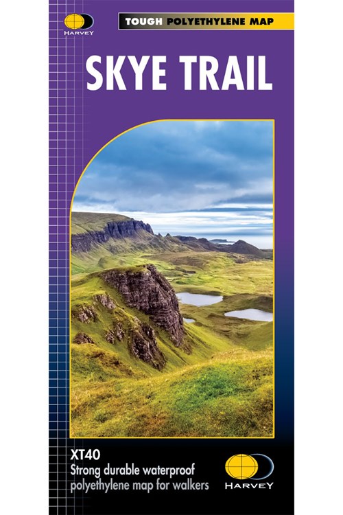
MCC203 Skye Trail Trail Map
15.95
- Home
- Equipment
- Walking Equipment
- Maps & Compasses
- Skye Trail Trail Map

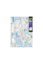
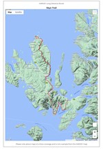
Entire route on one map
The Skye Trail is a challenging unmarked route of 127km (79 miles) through the island of Skye. It is specifically aimed at experienced hillwalkers.
The route follows much of the amazing Trotternish Ridge and passes beneath the peaks and pinnacles of the Cuillin, which are considered to be the finest mountains in Britain. There are also remarkable coastal cliffs, steep trails, high drops and haunting ruins of deserted villages destroyed in the highland clearances. You have various choices of alternative routes through either tough terrain or easier walking with spectacular mountain views and coastal scenery. It is not waymarked making this map an essential piece of your equipment.
• Tough, light, durable and 100% waterproof
• Genuine original HARVEY mapping
• Route clearly marked
• The map is conveniently laid out in panels so you only carry the mapping you need
Technical Specification
• Scale: 1:40,000
• Ratio: 2.5cm = 1km
• Flat size: 696 x 486mm
• Folded size: 116 x 243mm
• Weight: 35gms
• Double sided
• Format: strip map
Code: MCC203The Skye Trail is a challenging unmarked route of 127km (79 miles) through the island of Skye. It is specifically aimed at experienced hillwalkers.
The route follows much of the amazing Trotternish Ridge and passes beneath the peaks and pinnacles of the Cuillin, which are considered to be the finest mountains in Britain. There are also remarkable coastal cliffs, steep trails, high drops and haunting ruins of deserted villages destroyed in the highland clearances. You have various choices of alternative routes through either tough terrain or easier walking with spectacular mountain views and coastal scenery. It is not waymarked making this map an essential piece of your equipment.
• Tough, light, durable and 100% waterproof
• Genuine original HARVEY mapping
• Route clearly marked
• The map is conveniently laid out in panels so you only carry the mapping you need
Technical Specification
• Scale: 1:40,000
• Ratio: 2.5cm = 1km
• Flat size: 696 x 486mm
• Folded size: 116 x 243mm
• Weight: 35gms
• Double sided
• Format: strip map
Product Details
Entire route on one map
The Skye Trail is a challenging unmarked route of 127km (79 miles) through the island of Skye. It is specifically aimed at experienced hillwalkers.
The route follows much of the amazing Trotternish Ridge and passes beneath the peaks and pinnacles of the Cuillin, which are considered to be the finest mountains in Britain. There are also remarkable coastal cliffs, steep trails, high drops and haunting ruins of deserted villages destroyed in the highland clearances. You have various choices of alternative routes through either tough terrain or easier walking with spectacular mountain views and coastal scenery. It is not waymarked making this map an essential piece of your equipment.
• Tough, light, durable and 100% waterproof
• Genuine original HARVEY mapping
• Route clearly marked
• The map is conveniently laid out in panels so you only carry the mapping you need
Technical Specification
• Scale: 1:40,000
• Ratio: 2.5cm = 1km
• Flat size: 696 x 486mm
• Folded size: 116 x 243mm
• Weight: 35gms
• Double sided
• Format: strip map
Code: MCC203The Skye Trail is a challenging unmarked route of 127km (79 miles) through the island of Skye. It is specifically aimed at experienced hillwalkers.
The route follows much of the amazing Trotternish Ridge and passes beneath the peaks and pinnacles of the Cuillin, which are considered to be the finest mountains in Britain. There are also remarkable coastal cliffs, steep trails, high drops and haunting ruins of deserted villages destroyed in the highland clearances. You have various choices of alternative routes through either tough terrain or easier walking with spectacular mountain views and coastal scenery. It is not waymarked making this map an essential piece of your equipment.
• Tough, light, durable and 100% waterproof
• Genuine original HARVEY mapping
• Route clearly marked
• The map is conveniently laid out in panels so you only carry the mapping you need
Technical Specification
• Scale: 1:40,000
• Ratio: 2.5cm = 1km
• Flat size: 696 x 486mm
• Folded size: 116 x 243mm
• Weight: 35gms
• Double sided
• Format: strip map
Delivery & Returns
UK Deliveries
- FREE UK Standard Delivery within 3-5 working days on orders over £20
- £2.50 UK Standard Delivery on orders under £20
- £3.95 UK Mainland Express Delivery within 2-3 working days
- Orders are sent via Royal Mail
UK Return & Refund Policy
- Orders can be returned within 60 days of receipt
- The products must be in their original packaging, with all tags and in original condition
- Customers are responsible for return shipping costs, except for products that are faulty or damaged upon delivery
- For faulty or damaged items, please contact Mountain warehouse Customer Service team
Return method:
- Pack the items to be sent back securely in suitable protective packaging
- Print and fill out the return slip, and make sure to include it inside the package you're returning.
- Post your item to the address below and keep the tracking receipt as proof of return. For your convenience, follow here to the Royal Mail Returns Portal/Parcel2Go to arrange return postage for your items. These are not Mountain Warehouse operated services.
- Please retain proof of postage until it has been confirmed that your refund has been processed.
- Please note that items sold by HARVEY Maps cannot be returned to Mountain Warehouse stores
Return address:
Returns
HARVEY Maps
12-22 Main Street
Doune
FK16 6BJ
For more information or help, please contact Mountain Warehouse's Customer Care.